
Oʻahu has 5 of the world’s 13 climate sub-zones under the Köppen classification, and 2 of its 5 major zones. It’s the mildest of the four main islands: no true arid zone, and nothing high enough to turn alpine. Oʻahu’s variation comes almost entirely from one divide.
The Koʻolau Range runs down the windward side like a wall. Trade winds pile into it and drop their rain on the northeast slopes, which stay green and showery, while the leeward side from Honolulu out to Waiʻanae sits in the rain shadow and stays dry and sunny. Kāneʻohe takes about 67 inches of rain a year. Waikīkī, ten miles away over the ridge, takes 26.
For the trip-planning version of this map, month-by-month rainfall, temperatures and cloud cover for both sides of the ridge, see our Oʻahu weather guide.
Table of contents
How many climate zones does Oʻahu have?
Oʻahu packs 5 climate zones into about 600 square miles. The count depends on which system you use, and the most widely used is the Köppen scheme (Wikipedia, or explained in Hydrology and Earth System Sciences). It sorts the planet into 5 major climate zones, then splits those into 13 sub-zones.
Following the Köppen scheme, Oʻahu has 2 of the world’s 5 major climate zones and 5 of the 13 sub-zones. That’s the narrowest climate range of the main islands.
We marked these zones on the map below. On Oʻahu the legend colors line up one to one with the Köppen zones, so 5 colors means 5 zones. On the taller islands that’s not always true.
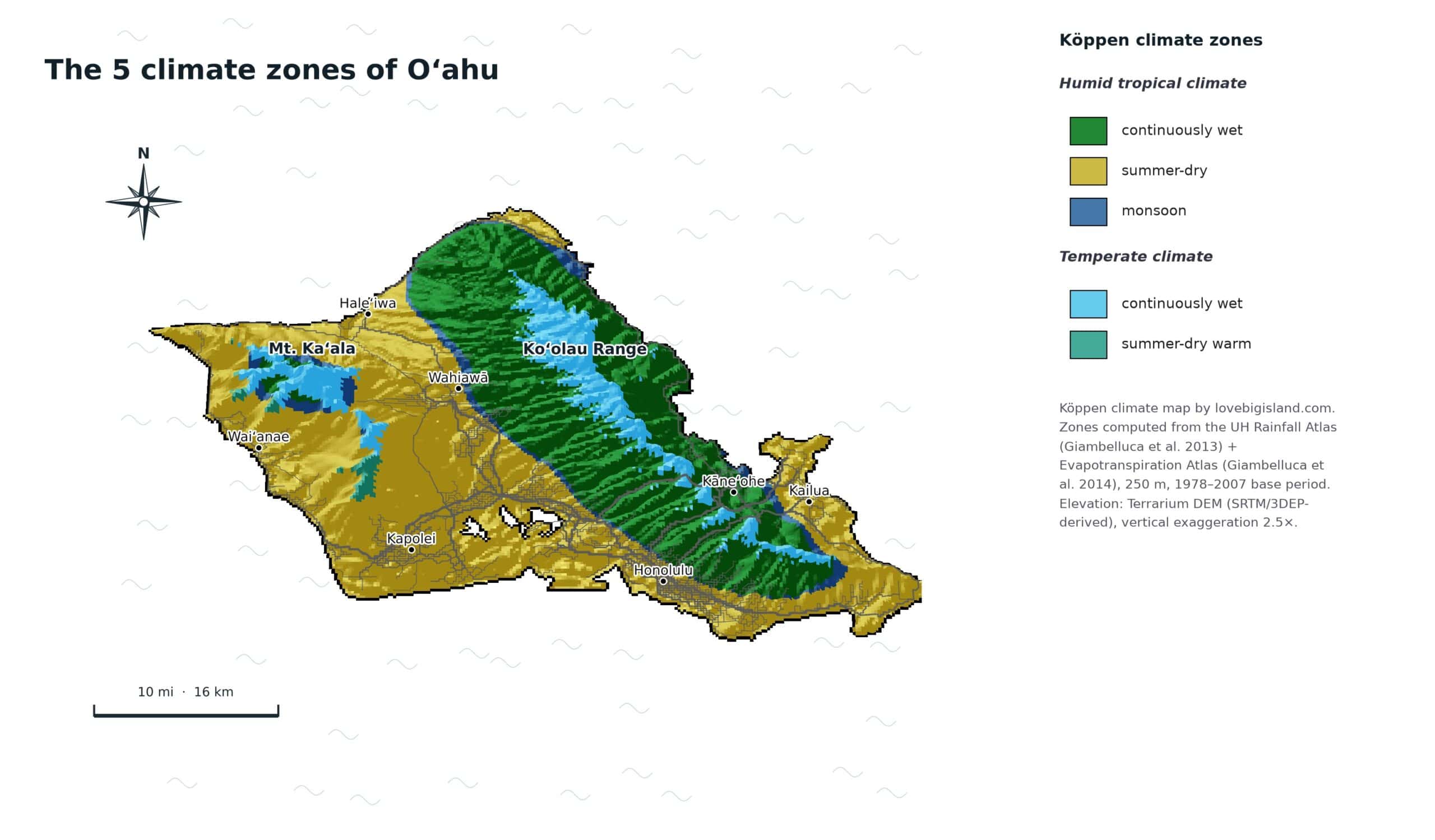
Climate map of Oʻahu. All 5 legend colors are distinct Köppen zones. The Koʻolau Range divides the wet windward side from the dry leeward one.
Which climate zones are NOT on Oʻahu?
Eight of the world’s 13 sub-zones don’t reach Oʻahu. Where one turns up elsewhere in the state, we note it:
- Dry semi-arid, steppe (found on Kauaʻi, Maui, and the Big Island)
- Dry arid, true desert (found on the Big Island)
- Polar tundra (found on Maui and the Big Island)
- Temperate winter dry
- Continental winter dry
- Continental summer dry
- Continental continuously wet
- Polar ice caps
The two that a visitor notices are the missing ends of the range. Oʻahu has no dry country like Maui’s Kīhei or the Big Island’s Kona, and no summit cold enough for the tundra you find on Haleakalā or Mauna Kea. Its high point, Mount Kaʻala in the Waiʻanae Range, reaches 4,003 feet and stays warm-temperate rather than alpine.
How Oʻahu compares to the other islands
Five zones are on all four main islands: tropical continuously wet, monsoon, tropical dry, temperate summer-dry, and temperate continuously wet. Only three zones separate the islands, and they stack in one order: whatever a smaller island has, the bigger ones have too.
- Big Island, 8 zones: the only true desert in the state, plus tundra on Mauna Kea and Mauna Loa.
- Maui, 7 zones: tundra on Haleakalā and steppe at Kīhei, but no desert.
- Kauaʻi, 6 zones: steppe on the west coast, and no summit high enough for tundra.
- Oʻahu, 5 zones: the narrowest range of the four, missing both dry zones and the tundra.
Oʻahu misses both limits. Tundra needs roughly 8,900 feet, and Mount Kaʻala, the island’s high point, stops near 4,000. At the dry end nothing here classifies as steppe or desert: the driest zone is tropical dry, running 3 to 1,281 feet across Honolulu and the ʻEwa plain.
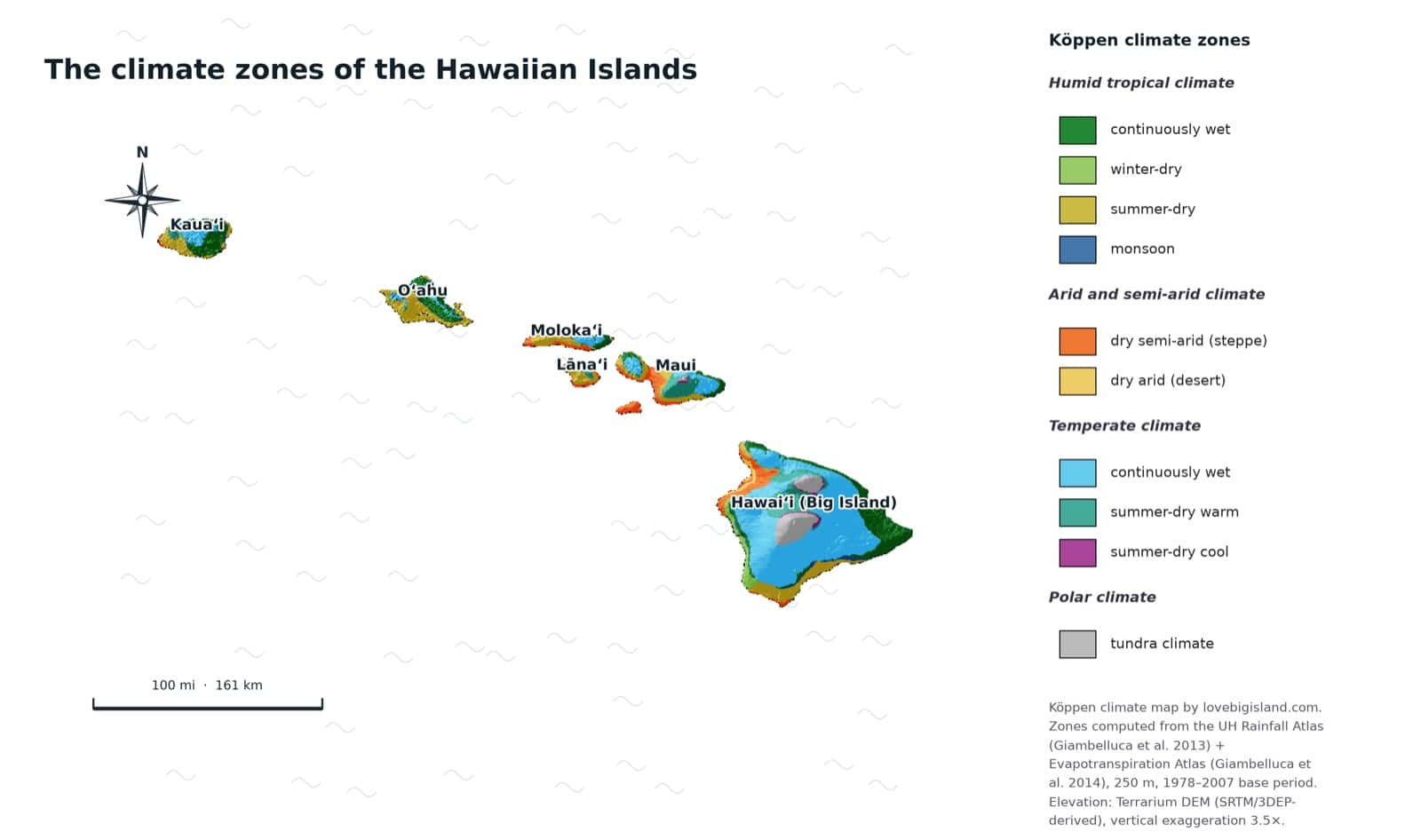
The climate zones of all Hawaiian islands on one map. The state spans 8 of the world’s 13 zones, and every one of them is found on the Big Island.
For when to come rather than where to stand, see the best time to visit Oʻahu.
The 5 Oʻahu climate zones, region by region
The 5 zones sort into two families: three tropical, two temperate.
| Zone | Elevation band | Where it sits |
|---|---|---|
| Tropical dry | 3 to 1,281 ft | Honolulu and Waikīkī, the ʻEwa plain, and the North Shore |
| Monsoon | 6 to 1,638 ft | The windward coast around Lāʻie and Kahuku |
| Tropical continuously wet | 61 to 1,510 ft | The windward strip from Kāneʻohe north, and the back of Mānoa |
| Temperate continuously wet | 1,602 to 2,728 ft | The high Koʻolau crest and the summit of Mount Kaʻala |
| Temperate summer dry | 1,853 to 2,625 ft | The drier interior slopes of the Waiʻanae Range |
Bands are where each zone mostly sits, not hard lines.
Humid Tropical climate
In these climates every month averages warmer than 64° F (18° C) and rain is plentiful. All three tropical sub-zones appear on Oʻahu, sorted by how the rain falls across the year.
Continuously wet
No real dry season. Rain all year. This is the windward rainforest on the Koʻolau slopes and crest, and it covers about a third of the island. Color on the map
Where to find it on Oʻahu: the whole windward strip from Kāneʻohe up the coast through Kahaluʻu, Kaʻaʻawa and Punaluʻu, plus the back of Mānoa valley behind Honolulu, where the mountains wring the rain out of the trades. Most of the island’s waterfall hikes sit in this zone. Our sister site Love Oʻahu has the waterfall guide.
Elevation: mostly 61 to 1,510 ft.
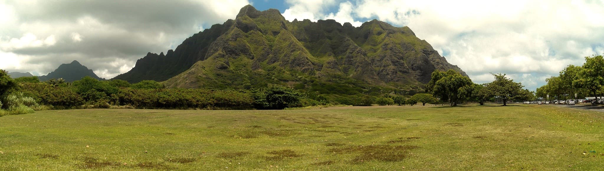
The windward face of the Koʻolau Range from Kualoa Regional Park, where rain falls in every month of the year. Image credit: Daniel Ramirez, source.
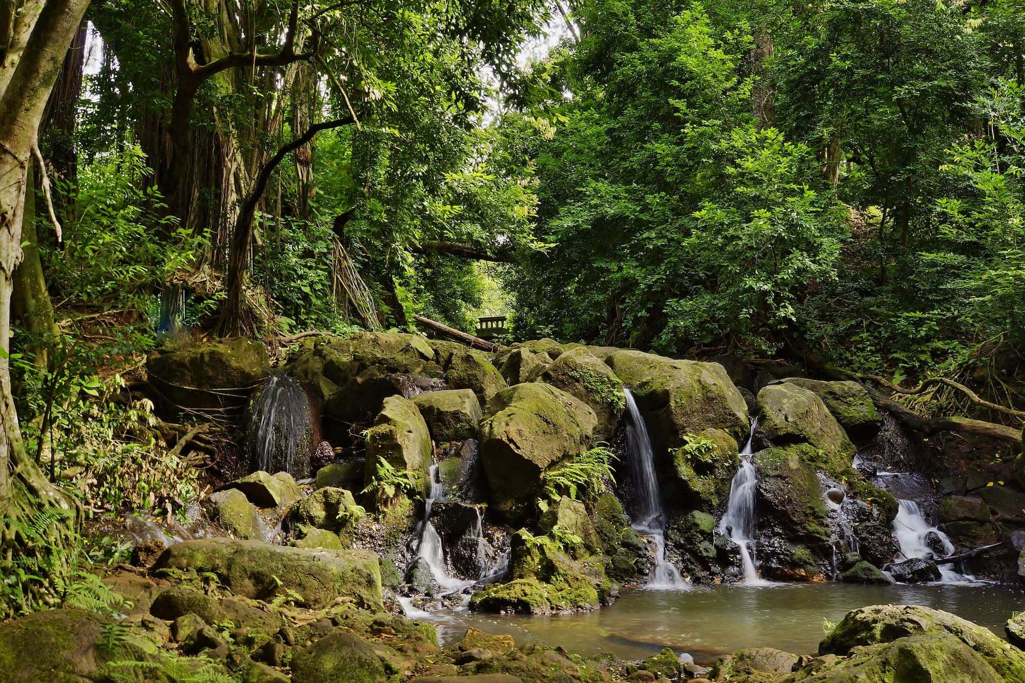
Nuʻuanu sits on the wet side of the divide, a few minutes above downtown Honolulu. This small waterfall, known as the “Ginger Pool”, sits at the start of the Nuʻuanu Pali area on the Judd Trail. Source: Eric Tessmer via Flickr CC BY-ND 2.0
Monsoon
A short dry season, but enough rain the rest of the year to keep the ground wet. On Oʻahu this is the thinnest zone of the five, about 4% of the island. It doesn’t form one block: it appears as narrow transition slivers wherever the continuously wet ground grades into the drier lowlands. Color on the map
Where to find it on Oʻahu: the largest patch is the windward coast around Lāʻie and Kahuku. Thinner bands run behind Kāneʻohe and Kailua, and along the north slopes of the Waiʻanae Range. The towns themselves sit just outside it.
Elevation: mostly 6 to 1,638 ft.
Dry
A clear dry season, here in the summer. This is the largest zone on Oʻahu, just over half the island, covering everything that dries out west and south of the mountains. Color on the map
Where to find it on Oʻahu: Honolulu and Waikīkī, the ʻEwa plain and Kapolei, the Waiʻanae coast, Wahiawā and central Oʻahu, the North Shore around Haleʻiwa, and windward Kailua and Waimānalo. Kailua gets more rain than Waikīkī, 38 inches against 26, but its dry summer still puts it in the same Köppen zone.
Elevation: mostly 3 to 1,281 ft.
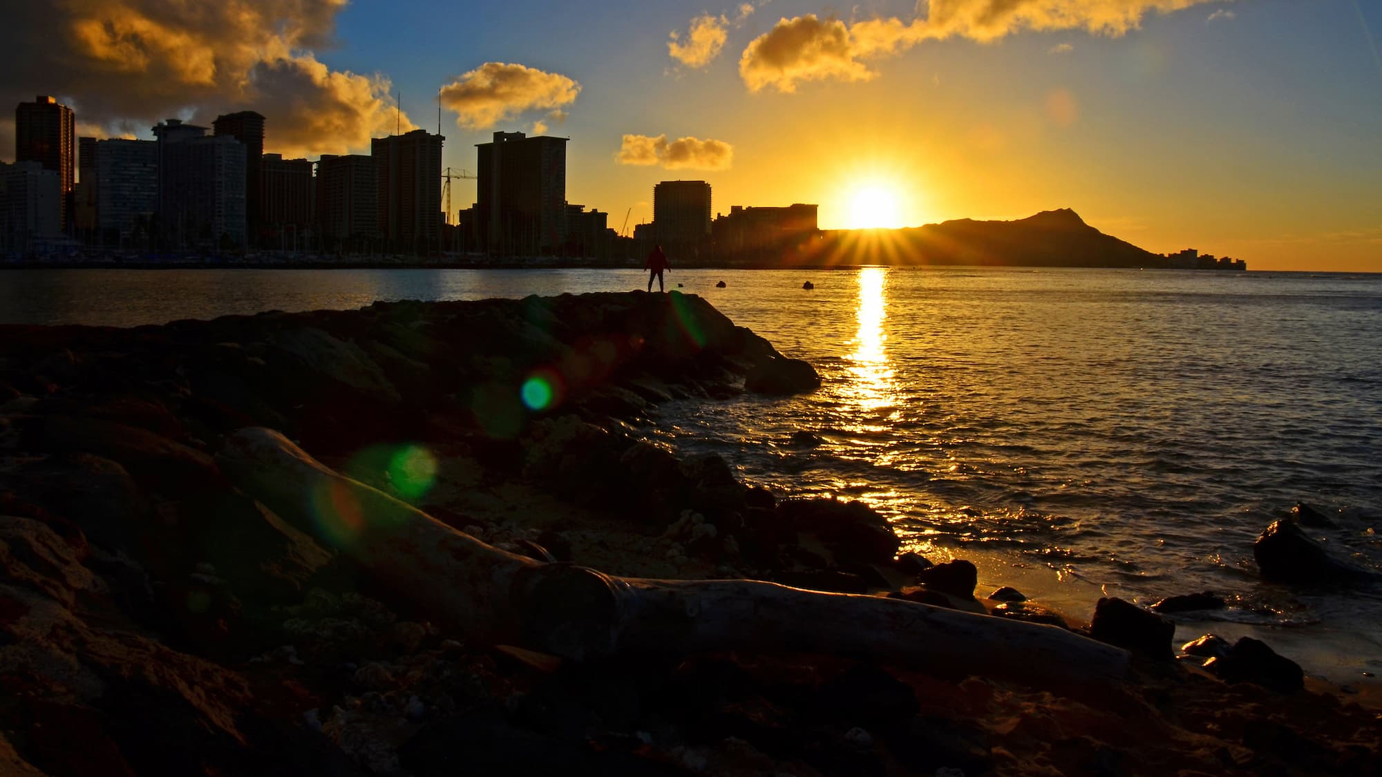
Waikīkī, in the rain shadow of the Koʻolau Range, takes about 26 inches of rain a year. Image credit: Edmund Garman, source.
Temperate climate
The coldest month averages between 27° F (-3° C) and 64° F (18° C), and the warmest month is above 50° F (10° C). Two sub-zones appear on Oʻahu, both on the high ground.
Continuously wet
At least 30 mm of rain in the driest month, with a smaller swing between wet and dry. These are the cool, wet tops of the two ranges. Color on the map
Where to find it on Oʻahu: the high Koʻolau crest, which takes around 117 inches of rain a year, and the summit of Mount Kaʻala in the Waiʻanae Range. Both are cool and often in cloud. Love Oʻahu has the trail guide if you want to walk up into them.
Elevation: mostly 1,602 to 2,728 ft.
Summer dry
At least three times as much rain in the wettest winter month as in the driest summer month. The smallest zone on the island, a warm dry-summer pocket in the uplands. Color on the map
Where to find it on Oʻahu: the drier interior slopes of the Waiʻanae Range, above the leeward coast.
Elevation: mostly 1,853 to 2,625 ft.
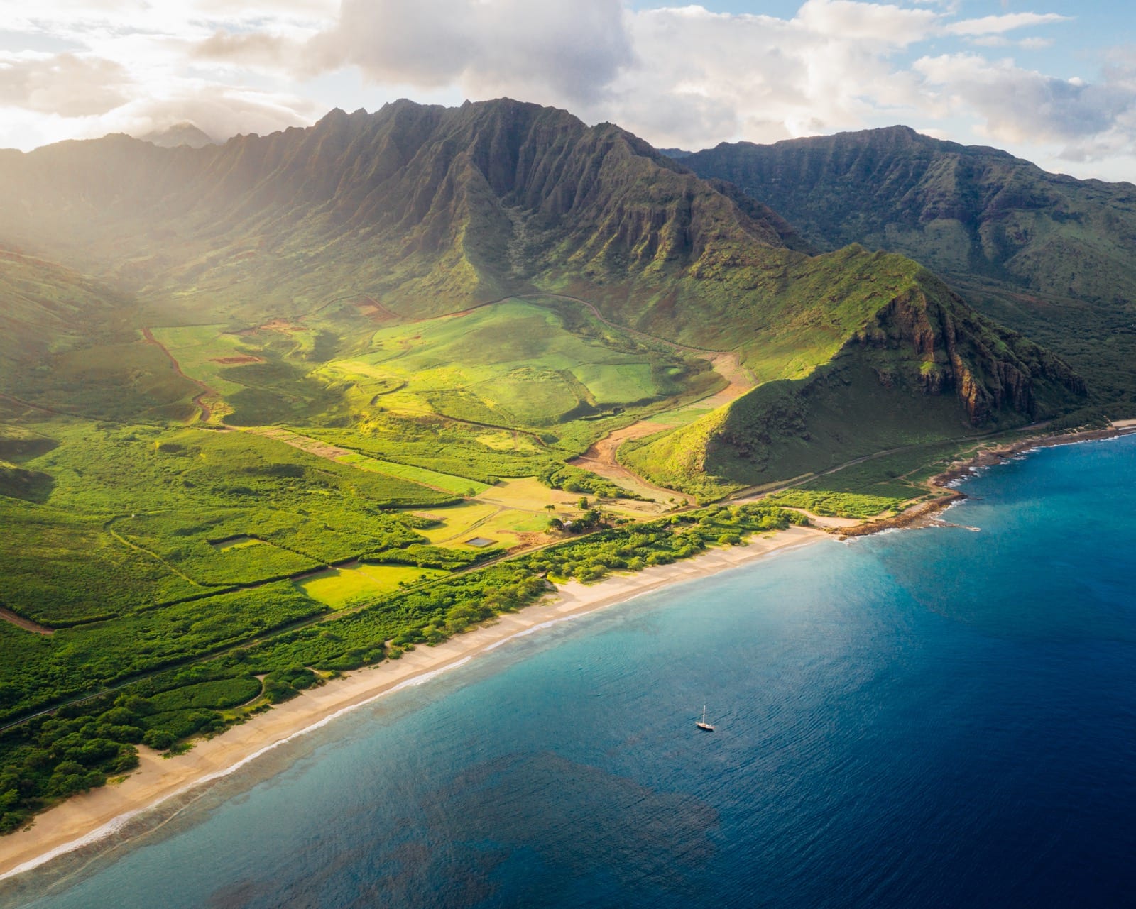
The Waiʻanae Range holds the island’s only dry-summer temperate pocket. Makua Valley sits on Oʻahu’s leeward (west) coast, in the foothills. Credit: Hawaii Tourism Authority (HTA) / Vincent Lim
Watch Oʻahu’s climate zones move through the year
Twelve snapshots, one per month. Each frame below classifies the island from that month’s warmth and rainfall alone, the two things the Köppen map above averages over a whole year. A real Köppen zone only exists once that averaging is done, so read the loop as the moving parts underneath the map, not as a monthly version of it.
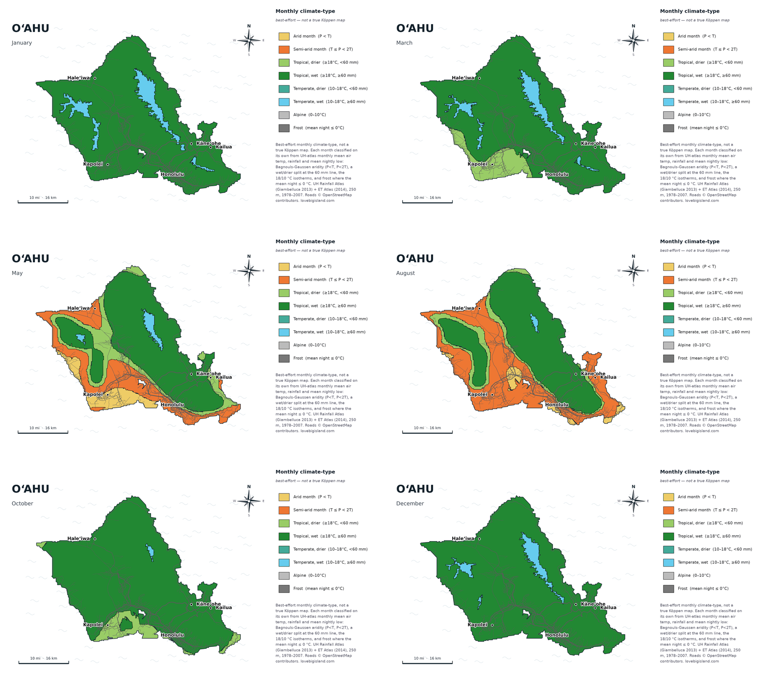
Oʻahu through the year: the leeward dry zone spreads from the ʻEwa plain to the Waiʻanae coast each summer while the windward Koʻolau stays wet. Data: Giambelluca et al. (2013, 2014), 250 m grid. Map by Love Big Island.
Watch the leeward plain. Through winter Oʻahu reads almost entirely green. Through summer a wide dry zone opens across the whole leeward side, from the ʻEwa plain and Kapolei out along the Waiʻanae coast, while the windward Koʻolau stays wet the year round. It is the clearest split of any island here: the dry side and the wet side of Oʻahu are never further apart than at the height of summer, and by late fall the rain returns and the gap narrows again.
The classification runs on University of Hawaiʻi atlas data, month by month: rainfall set against temperature decides wet or dry, and temperature decides warm or cool. It shows the average shape of a year, not what any particular January will do.
How we counted the zones
The count of 5 sub-zones on Oʻahu uses the most common form of the Köppen classification, the same one we use across this series. Köppen is a 3-tier system: 5 main climates in the first tier, splitting into 13 sub-zones in the second, and into 28 or 30 finer groups in the third. When we say Oʻahu has 5 of the world’s 13, we mean the second tier.
On Oʻahu the map’s colors match the Köppen zones one for one, so counting the colors gives the right answer. That’s not always the case. On the Big Island we split two zones into two shades each for readers, which is how that map ends up with 10 colors for 8 zones. Oʻahu needs no such split.
Our zones are computed from the University of Hawaiʻi Rainfall Atlas (Giambelluca et al. 2013) and Evapotranspiration Atlas (Giambelluca et al. 2014) at 250 m resolution. We feed the monthly rainfall and temperature for every 250 m pixel through the standard Köppen decision rules set out by Peel, Finlayson, and McMahon (2007). That resolution is fine enough to pick out the narrow wet band along the Koʻolau crest that a coarser map would blur into the lowlands.
Explore the data yourself: the UH Hawaiʻi Climate Data Portal publishes interactive climate maps, live readings from the Hawaiʻi Mesonet station network (live data), and monthly climate summaries.
The base period is 1978 to 2007. Climate zones are built on 30-year normals, so they barely shift between one recent period and the next. A finer grid changes the map more than a different 30-year window does.
The elevation bands come from the same 250 m grid, sampled against a public terrain model: each one is the range the middle 90 percent of that zone’s pixels fall in. They describe where a zone mostly sits rather than a hard line, because the zones interleave windward and leeward and neither side changes at the same height.
New to the island? Start with our Oʻahu guide for first-time visitors.